Other Lambeth Mills

Other Lambeth Mills

lambeth mills
Image: Copyright © London Borough of Lambeth/ Lambeth Archives

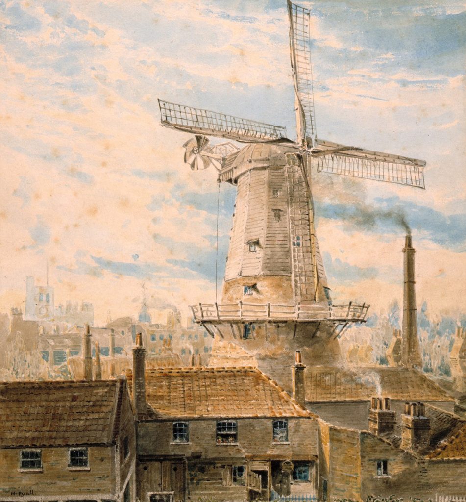
Today Brixton has London’s last working windmill, but go back in time and you would have seen lots more locally and across the city.

Many of the things we buy used to be made locally. London was surrounded by fields and farmers could bring their grain directly to windmills to be made into flour for bread.  But windmills were important for other things too — grinding drugs and spices, and using their wind power to saw wood and pump water.

Then the Industrial Revolution came and London grew bigger in the middle of the 19th century. Fields and farms were replaced by houses and shops, and windmills like Brixton’s got less wind as buildings sprung up around them.

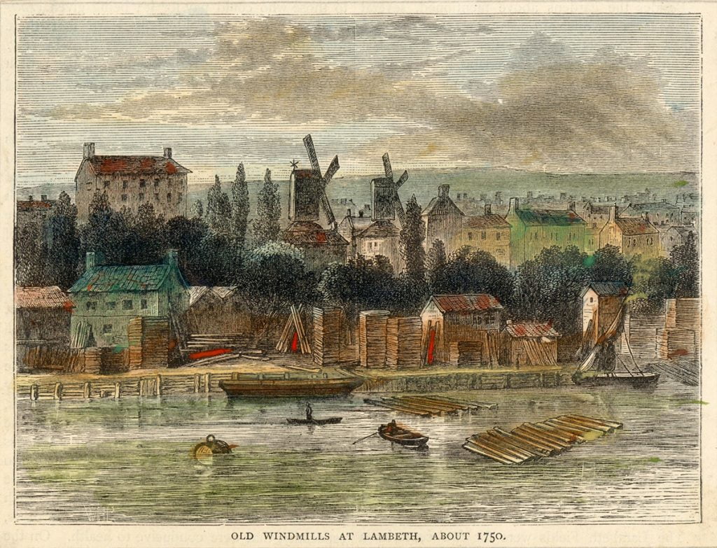
The earliest windmill in Lambeth we know of is from the 16th century, although there were probably mills before then too. There have been at least 12 windmills in Lambeth at different times — the maximum number at any one time was the beginning of the 19th century, when there were five including Brixton Windmill. Explore more of Lambeth’s windmills on a map.

Morrish Road, Brixton Hill

This octagon-shaped smock mill was about a third of a mile south of Brixton Windmill, on what is now Morrish Road. It first appeared on a map of south London dated 1800, and a sketch of 1803 shows it with a waggon-shaped cap.

A miller from the mill at Westow Hill, John Paddy, seems to have moved here in 1839. The mill disappeared soon after 1844, and there is no trace today.

Morrish Road Windmill
Near Brixton Hill, watercolour, by G. Harley, 1818 Image: Copyright © London Borough of Lambeth/ Lambeth Archives

South Bank

This post mill first appeared on a map in 1658 and stood where the Royal Festival Hall is today. It was a square sawmill, known in Holland as a “paltrok” mill because its shape resembled the dress of women in the Zaan district. Illustrations from the 17th century show a square body among low buildings and piles of timber a few yards from the water’s edge.

North Lambeth Mill
Image: Copyright © London Borough of Lambeth/ Lambeth Archives

The Cut, Waterloo

This was an octagon-shaped smock mill standing on what is now Cons Street (formerly Little Windmill Street). It was built on a three-storey base and had four common sails.

Although the mill was shown on maps as early as 1794, we don’t know the exact date it was built. It was demolished some time between 1816 and 1819.

The Cut Mill
A mill in Lambeth Marsh Road, watercolour, by H. de Cort, 1804 Image: Copyright © London Borough of Lambeth/ Lambeth Archives

Ethelred Street, Kennington

This was known as the Lambeth drug mill and it was leased by drug makers and apothecaries (pharmacists who made their own medicines) for several years.

It was one of three mills in the area of Lambeth Walk and it first appeared on maps in the mid-18th century but had disappeared by the 19th century. A watercolour painting from 1780 shows it as a three-storey tower mill with a stage at first-floor level and an oddly shaped cap with an unusually long windshaft sticking out at the front.

Ethelred St Mill
Engraving, 1789 of original drawing Paul Sanby RA Image: Copyright © London Borough of Lambeth/ Lambeth Archives

Juxon Street, Kennington

This tall, ten-sided smock mill was the most northerly of three windmills built around Lambeth Walk in the 18th century. A picture of the Thames from around 1830 shows it to the right of Lambeth Palace if you were looking from the river, about two-thirds the height of Lambeth Church tower.

The mill was used to grind drugs until 1867. It was demolished to make way for the London and South Western Railway extension and housing.

Juxon Street Mill
Juxon Street, watercolour by H. Pyall, 1820 Image: Copyright © London Borough of Lambeth/ Lambeth Archives

Randall's Mill, Nine Elms

By the early 19th century there seem to have been at least three windmills and a watermill in the Nine Elms area. The one known as Randall’s Mill sat right on the bank of the Thames, by the creek of the River Effra.

An 18th-century watercolour painting shows it as a stone-built tower mill with three storeys above the wharf level and four common sails. Later illustrations show double-shuttered sails and a fantail.

It’s not clear whether the mill was used for grinding corn, it may have been connected with a local cement factory or china mill. It was probably another victim of the expansion of the railway lines from Waterloo.

Randalls Mill
Near Vauxhall Bridge: lithograph, by by F.E. Martens, 1829 Image: Copyright © London Borough of Lambeth/ Lambeth Archives

Westow Hill, Upper Norwood

This mill was at the back of what is now 30 Westow Hill. It first appeared in historical records in 1813, and had quite a turnover of tenants  until it was pulled down in the 1850s.

The records of the Ashby family of Brixton Windmill show they were commissioned to do some repairs and alterations to the Westow Hill mill in the 1830s, including fitting patent sails and fitting new mill stones. But they seem to have had some trouble getting paid!

Westow Hill Windmill
Image: Copyright © London Borough of Lambeth/ Lambeth Archives

Crown Point, Norwood

It is difficult to work out the location of this windmill because of the way it was shown on maps of the 16th and 17th centuries, but it seems to have been somewhere around the Crown Point area.

There are no pictures of the mill, but it’s likely to have been a small post mill similar to the mill on Clapham Common, and it was probably used for grinding corn.

photo of a post mill
Image: A post mill - the mill at Crown Point is likely to have been a similar type to this / Wikimedia Commons

Clapham Common

We know very little about this mill. The earliest maps that still exist of Clapham are from the 18th century and show the Windmill Inn but not the windmill itself, and there are no pictures of the original mill.

However, a lease from 1631 lists the contents of the mill (rental £8 a year), though it doesn’t give the exact location. There is also a possibility the mill was moved to the common from Balham Wood Lane (now Nightingale Lane).

The green in front of the Windmill pub on Clapham Common
Image: The green in front of the Windmill pub on Clapham Common today. Chris Reynolds / geograph.org.uk / CC BY-SA 2.0

Whitgift Street, Vauxhall

This stood roughly where the railway arch now crosses Whitgift Street (opposite the Windmill pub). This smock mill was probably used to produce mustard and starch before switching to flour production.

Like the mill on Juxon Street, its demise was due to the growth of the railways. The three-storey stone base supported an octagonal body covered in horizontal weatherboarding.

The Windmill pub on Whitgift Street
Image: The Windmill pub on Whitgift Street today / © Google 2019

Knight's Hill, Tulse Hill

The first edition of the one-inch Ordnance Survey map, published around 1816, shows a windmill on the summit of the hill that now stands above the southerly mouth of the railway tunnel to Tulse Hill station.

The mill seems to have been short-lived, as it is not marked on maps of the 1840s. There is no documentary evidence to show what it was like or what happened to it.

Knight's Hill Tunnel by Tulse Hill station
Image: Knight's Hill Tunnel by Tulse Hill station today / Flickr @dfisher81 / CC BY-NC-ND 2.0